
Fast computation of isochrones from a given location. The
function can return either polygon-based or line-based isochrones.
Polygon-based isochrones are generated from a travel time surface: travel
times from each origin to the centres of a regular grid of Web Mercator
pixels (see zoom), from which the isochrone polygons are interpolated with
the marching squares algorithm. Line-based isochrones are based on
travel times from each origin to the centroids of all segments in the
transport network.
Usage
isochrone(
  r5r_network,
  origins,
  mode = "transit",
  mode_egress = "walk",
  cutoffs = c(0, 15, 30),
  zoom = 10,
  departure_datetime = Sys.time(),
  polygon_output = TRUE,
  time_window = 10L,
  max_walk_time = Inf,
  max_bike_time = Inf,
  max_car_time = Inf,
  max_trip_duration = 120L,
  walk_speed = 3.6,
  bike_speed = 12,
  max_rides = 3,
  max_lts = 2,
  draws_per_minute = 5L,
  percentiles = NULL,
  n_threads = Inf,
  verbose = FALSE,
  progress = TRUE,
  sample_size = deprecated(),
  r5r_core = deprecated()
)
Arguments
- r5r_network
A routable transport network created with
build_network().- origins
Either a
POINT sfobject with WGS84 CRS, or adata.framecontaining the columnsid,lonandlat.- mode
A character vector. The transport modes allowed for access, transfer and vehicle legs of the trips. Defaults to
TRANSIT. See details for other options.- mode_egress
A character vector. The transport mode used after egress from the last public transport. It can be either
WALK,BICYCLEorCAR. Defaults toWALK. Ignored when public transport is not used.- cutoffs
A numeric vector. The travel times, in minutes, that delimit the isochrones. Defaults to
c(0, 15, 30). Values are sorted and duplicates are removed; at least one value must be greater than 0.- zoom
A number between 9 and 12. The Web Mercator zoom level of the travel time grid from which polygon isochrones are interpolated (only used when
polygon_output = TRUE). Higher values give more detailed isochrones but take longer to compute. Defaults to 10 (cells of about 153 meters at the Equator). For how grid cells are defined, see the R5 documentation.- departure_datetime
A POSIXct object. Only affects public transport legs; when routing with public transport, it must fall within the service period of the GTFS feeds (
calendar.txt; seecheck_transit_availability()). Defaults toSys.time(). See details for how datetimes are parsed.- polygon_output
A Logical. If
TRUE, the function outputs polygon-based isochrones (the default) based on travel times from each origin to a regular grid of points (see parameterzoom). IfFALSE, the function outputs line-based isochrones based on travel times from each origin to the centroids of all segments in the transport network.- time_window
An integer. The time window in minutes. Departures are simulated every minute from
departure_datetimeuntiltime_windowminutes later, and travel times are summarized over these departures usingpercentiles(the median by default). Defaults to 10. Seevignette("time_window", package = "r5r").- max_walk_time
An integer. The maximum walking time (in minutes) to access and egress the transit network, make transfers, or complete walk-only trips. Applies to each leg separately (e.g.
15allows up to 15 minutes to reach transit and another 15 after leaving it). Defaults toInf(no limit besidesmax_trip_duration). In walk-only trips, the lower ofmax_walk_timeandmax_trip_durationapplies.- max_bike_time
An integer. The maximum cycling time (in minutes) to access and egress the transit network, make transfers, or complete bicycle-only trips. Applies to each leg separately (e.g.
15allows up to 15 minutes to reach transit and another 15 after leaving it). Defaults toInf(no limit besidesmax_trip_duration). In bicycle-only trips, the lower ofmax_bike_timeandmax_trip_durationapplies.- max_car_time
An integer. The maximum driving time (in minutes) to access and egress the transit network, or to complete car-only trips. Applies to each leg separately (e.g.
15allows up to 15 minutes to reach transit and another 15 after leaving it). Defaults toInf(no limit besidesmax_trip_duration). In car-only trips, the lower ofmax_car_timeandmax_trip_durationapplies.- max_trip_duration
Ignored. The maximum trip duration is set internally from
max(cutoffs).- walk_speed
A numeric. Average walk speed in km/h. Defaults to 3.6.
- bike_speed
A numeric. Average cycling speed in km/h. Defaults to 12.
- max_rides
An integer. The maximum number of public transport rides allowed in the same trip. Defaults to 3.
- max_lts
An integer between 1 and 4. The maximum level of traffic stress that cyclists will tolerate. A value of 1 means cyclists will only travel through the quietest streets, while a value of 4 indicates cyclists can travel through any road. Defaults to 2. See details.
- draws_per_minute
An integer. The number of Monte Carlo draws to perform per minute of
time_window. Defaults to 5. This would mean 300 draws in a 60-minute time window, for example. This parameter only affects the results when the GTFS feeds contain afrequencies.txttable. If the GTFS feed does not have a frequency table, r5r still allows for multiple runs over the settime_windowbut in a deterministic way.- percentiles
An integer vector (max length of 5). The travel time percentiles within
time_windowused to build the isochrones, one set of polygons per percentile. Defaults to 50 (the median travel time). Only used whenpolygon_output = TRUE; must beNULLfor line-based isochrones.- n_threads
An integer. The number of threads to use when running the router in parallel. Defaults to
Inf(all available threads).- verbose
A logical. Whether to show
R5informative messages when running the function. Defaults toFALSE(R5error messages are still shown).TRUEshows detailed output, useful for debugging issues not caught byr5r.- progress
A logical. Whether to show a progress counter when running the router. Defaults to
TRUE. Only works whenverboseisFALSE. May slightly slow computation, as the counter is synchronized across threads.- sample_size
deprecated, no longer has any effect.
- r5r_core
The
r5r_coreargument is deprecated as of r5r v2.3.0. Use ther5r_networkargument instead.
Value
A "sf" "data.frame". With polygon_output = TRUE, one POLYGON
or MULTIPOLYGON per origin, percentile and cutoff, with columns
id (origin id), isochrone (cutoff in minutes), percentile (a
string such as "p50") and polygons. Each polygon covers the whole
area reached from 0 up to its cutoff, so polygons of larger cutoffs
contain those of smaller ones. With polygon_output = FALSE, one
LINESTRING per street segment reached, with columns id (origin
id), edge_index, osm_id, isochrone (the smallest cutoff at or
above the segment's travel time, i.e. bands are intervals),
travel_time_p50 and geometry.
Transport modes
R5 allows for multiple combinations of transport modes. The options
include:
Transit modes:
TRAM,SUBWAY,RAIL,BUS,FERRY,CABLE_CAR,GONDOLA,FUNICULAR. The optionTRANSITautomatically considers all public transport modes available.Non transit modes:
WALK,BICYCLE,CAR.
Level of Traffic Stress (LTS)
When cycling is enabled in R5 (by passing the value BICYCLE to either
mode or mode_egress), setting max_lts will allow cycling only on
streets with a given level of danger/stress. Setting max_lts to 1, for
example, will allow cycling only on separated bicycle infrastructure or
low-traffic streets and routing will revert to walking when traversing any
links with LTS exceeding 1. Setting max_lts to 3 will allow cycling on
links with LTS 1, 2 or 3. Routing also reverts to walking if the street
segment is tagged as non-bikable in OSM (e.g. a staircase), independently of
the specified max LTS.
The default methodology for assigning LTS values to network edges is based on commonly tagged attributes of OSM ways. See more info about LTS in the original documentation of R5 from Conveyal at https://docs.conveyal.com/learn-more/traffic-stress. In summary:
LTS 1: Tolerable for children. This includes low-speed, low-volume streets, as well as those with separated bicycle facilities (such as parking-protected lanes or cycle tracks).
LTS 2: Tolerable for the mainstream adult population. This includes streets where cyclists have dedicated lanes and only have to interact with traffic at formal crossing.
LTS 3: Tolerable for "enthused and confident" cyclists. This includes streets which may involve close proximity to moderate- or high-speed vehicular traffic.
LTS 4: Tolerable only for "strong and fearless" cyclists. This includes streets where cyclists are required to mix with moderate- to high-speed vehicular traffic.
For advanced users, you can provide custom LTS values by adding a tag <key = "lts"> to the osm.pbf file.
Datetime parsing
r5r ignores the timezone attribute of datetime objects when parsing dates
and times, using the study area's timezone instead. For example, let's say
you are running some calculations using Rio de Janeiro, Brazil, as your study
area. The datetime as.POSIXct("13-05-2019 14:00:00", format = "%d-%m-%Y %H:%M:%S") will be parsed as May 13th, 2019, 14:00h in
Rio's local time, as expected. But as.POSIXct("13-05-2019 14:00:00", format = "%d-%m-%Y %H:%M:%S", tz = "Europe/Paris") will also be parsed as
the exact same date and time in Rio's local time, perhaps surprisingly,
ignoring the timezone attribute.
Routing algorithm
The travel_time_matrix(), expanded_travel_time_matrix(),
arrival_travel_time_matrix() and accessibility() functions use an
R5-specific extension to the RAPTOR routing algorithm (see Conway et al.,
2017). This RAPTOR extension uses a systematic sample of one departure per
minute over the time window set by the user in the 'time_window' parameter.
A detailed description of base RAPTOR can be found in Delling et al (2015).
However, whenever the user includes transit fares inputs to these functions,
they automatically switch to use an R5-specific extension to the McRAPTOR
routing algorithm.
Conway, M. W., Byrd, A., & van der Linden, M. (2017). Evidence-based transit and land use sketch planning using interactive accessibility methods on combined schedule and headway-based networks. Transportation Research Record, 2653(1), 45-53. doi:10.3141/2653-06
Delling, D., Pajor, T., & Werneck, R. F. (2015). Round-based public transit routing. Transportation Science, 49(3), 591-604. doi:10.1287/trsc.2014.0534
Examples
options(java.parameters = "-Xmx2G")
library(r5r)
library(ggplot2)
# build transport network
data_path <- system.file("extdata/poa", package = "r5r")
r5r_network <- build_network(data_path = data_path)
#> Using cached R5 version from /home/runner/.cache/R/r5r/r5_jar_v7.5.1/r5-v7.5-1-gf3631e9-all.jar
#> ℹ Using cached network from
#> /home/runner/work/_temp/Library/r5r/extdata/poa/network.dat.
# load origin/point of interest
points <- read.csv(file.path(data_path, "poa_points_of_interest.csv"))
origin <- points[2,]
departure_datetime <- as.POSIXct(
"13-05-2019 14:00:00",
format = "%d-%m-%Y %H:%M:%S"
)
# estimate polygon-based isochrone from origin
iso_poly <- isochrone(
r5r_network,
origins = origin,
mode = "walk",
polygon_output = TRUE,
departure_datetime = departure_datetime,
cutoffs = seq(0, 120, 30)
)
head(iso_poly)
#> Simple feature collection with 4 features and 3 fields
#> Geometry type: POLYGON
#> Dimension: XY
#> Bounding box: xmin: -51.25603 ymin: -30.0783 xmax: -51.16081 ymax: -29.99003
#> Geodetic CRS: WGS 84
#> id isochrone percentile polygons
#> 1 bus_central_station 120 p50 POLYGON ((-51.21071 -30.076...
#> 2 bus_central_station 90 p50 POLYGON ((-51.2114 -30.0637...
#> 3 bus_central_station 60 p50 POLYGON ((-51.21071 -30.048...
#> 4 bus_central_station 30 p50 POLYGON ((-51.21346 -30.035...
# estimate line-based isochrone from origin
iso_lines <- isochrone(
r5r_network,
origins = origin,
mode = "walk",
polygon_output = FALSE,
departure_datetime = departure_datetime,
cutoffs = seq(0, 100, 25)
)
head(iso_lines)
#> Simple feature collection with 6 features and 14 fields
#> Geometry type: LINESTRING
#> Dimension: XY
#> Bounding box: xmin: -51.18467 ymin: -30.05426 xmax: -51.17266 ymax: -30.02355
#> Geodetic CRS: WGS 84
#> id edge_index osm_id isochrone travel_time_p50 from_vertex
#> 1 bus_central_station 644 27238056 100 100 443
#> 2 bus_central_station 645 27238056 100 100 444
#> 3 bus_central_station 1048 27370379 100 100 717
#> 4 bus_central_station 1049 27370379 100 100 718
#> 5 bus_central_station 1058 27370382 100 100 722
#> 6 bus_central_station 1059 27370382 100 100 723
#> to_vertex street_class length walk car car_speed bicycle bicycle_lts
#> 1 444 TERTIARY 78.580 TRUE TRUE 39.996 TRUE 2
#> 2 443 TERTIARY 78.580 TRUE FALSE 39.996 FALSE 2
#> 3 718 OTHER 242.560 TRUE TRUE 40.248 TRUE 4
#> 4 717 OTHER 242.560 TRUE TRUE 40.248 TRUE 4
#> 5 723 OTHER 85.916 TRUE TRUE 40.248 TRUE 2
#> 6 722 OTHER 85.916 TRUE TRUE 40.248 TRUE 2
#> geometry
#> 1 LINESTRING (-51.17282 -30.0...
#> 2 LINESTRING (-51.17266 -30.0...
#> 3 LINESTRING (-51.18231 -30.0...
#> 4 LINESTRING (-51.18467 -30.0...
#> 5 LINESTRING (-51.18424 -30.0...
#> 6 LINESTRING (-51.1839 -30.05...
# plot colors
colors <- c('#ffe0a5','#ffcb69','#ffa600','#ff7c43','#f95d6a',
'#d45087','#a05195','#665191','#2f4b7c','#003f5c')
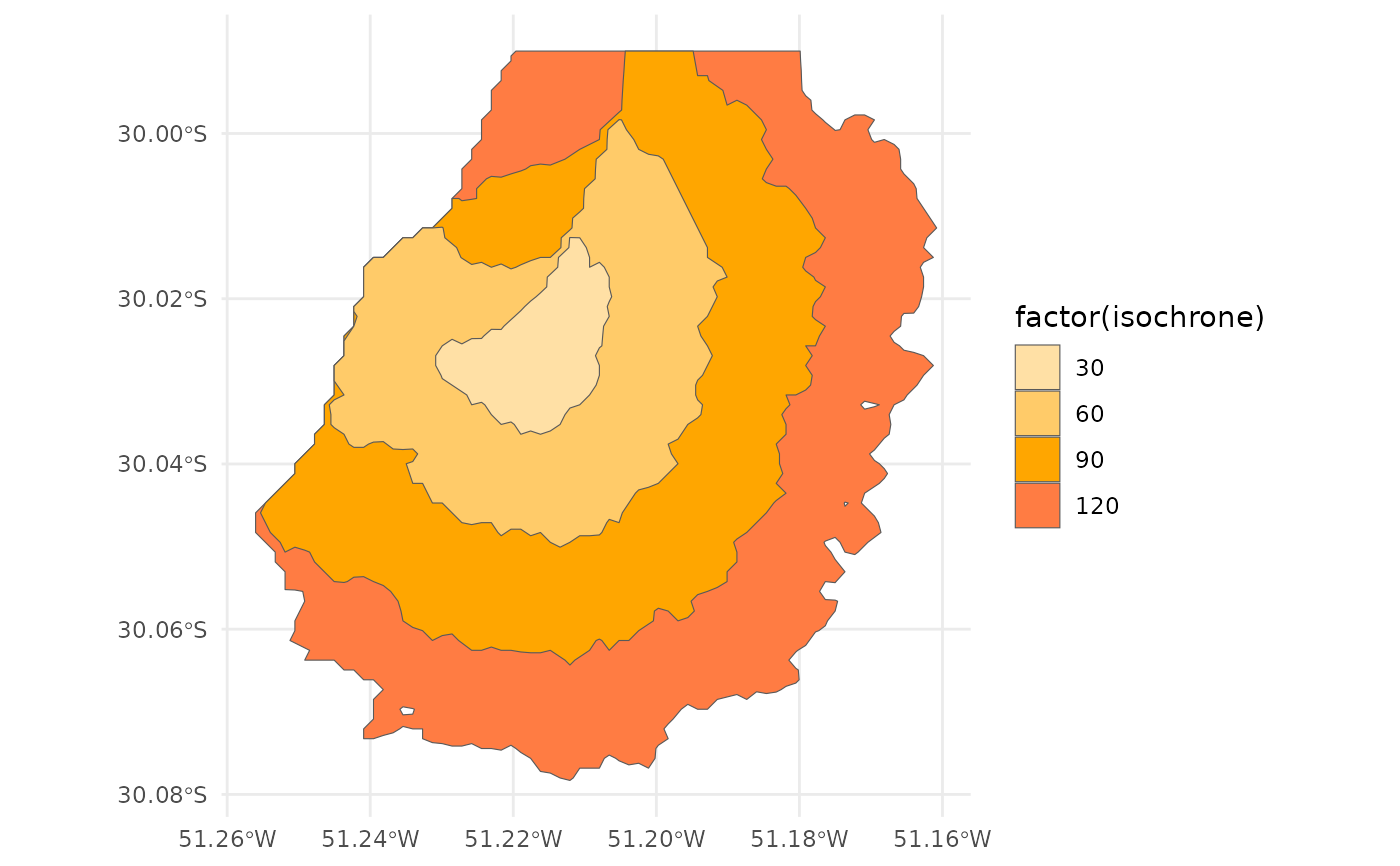
# polygons
ggplot() +
geom_sf(data=iso_poly, aes(fill=factor(isochrone))) +
scale_fill_manual(values = colors) +
theme_minimal()
 # lines
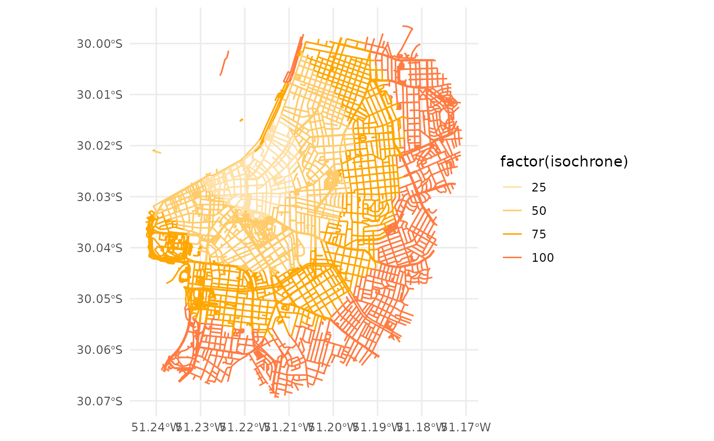
ggplot() +
geom_sf(data=iso_lines, aes(color=factor(isochrone))) +
scale_color_manual(values = colors) +
theme_minimal()
# lines
ggplot() +
geom_sf(data=iso_lines, aes(color=factor(isochrone))) +
scale_color_manual(values = colors) +
theme_minimal()
 stop_r5(r5r_network)
#> r5r_network has been successfully stopped.
stop_r5(r5r_network)
#> r5r_network has been successfully stopped.